

Gralhix OSINT 021 – Cocoardinates
Solution
The coordinates are: 41.35242908473371, -4.690351935061442. Check it on Google Maps here (the south is on top).
Log
I noticed the "Do it right" writing on the chocolate and I ran this Google search:
"do it right" "chocolate"
The first result was:

Figure 1: The very first Google result.
So I immediately searched for "puchero valladolid" in Google Maps and had a match.
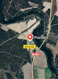
Figure 2: The general area of the match.
I recognized the trees that follow the Eresma River from the original map, which is actually "upside down" (South on top). Rotating the map in Google Maps:
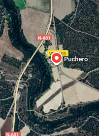
Figure 3: After rotating the map.
- The coordinates are: 41.35242908473371, -4.690351935061442.
Bonus
I realized later that the map is also on Puchero's website.
Itches
I like Geohashing, as introduced by xkcd. Basically, it's a playful algorithm for generating random daily coordinates. It combines the date with the day's Dow Jones opening value, takes the MD5 hash of the combination, convert the hexadecimal to decimal to create seemingly random but reproducible decimal coordinates within a given latitude/longitude region. The idea is for people to meet at these coordinates for exploration or social gatherings. It is a very fun motivation for spontaneous adventure! There's even a entire wiki dedicated to the activity with all kinds of challenges: camping at a geohash, reaching it at midnight, etc.
After this exercise, I wondered what could be the closest geohash to have landed near our target area since the "invention" of Geohashing. To check this, I used the Geohashing Shotgun application that displays all geohashes in a given area for a given period. And the winner is: 2014-12-1044-1! At the time of this writeup, 10 years ago in a few days 🙂🎄